A Russian Surveillance Mission over the US
Not to sound crazy, but the Russians are watching me! Don't panic though- it's all been approved under an international treaty.
When I posted earlier about how I'd been collecting and analyzing airline data for fun, a friend of mine asked if military planes show up in the data. The answer turned out to be "not much", but while I was looking into it I started reading up on different ways governments fly military missions around the world for political reasons. For example, there were several stories in the news last year about how Russia has been sending long-range bombers into other countries' airspaces, presumably to test their air defenses or provoke a reaction. It would be interesting to look for these incursions in my data, but unfortunately they don't show up because the bombers are operating covertly, with their location beacons turned off.

Another story in the news last year involving military avionics was that the US and Russia had several heated exchanges over overt, surveillance missions that were to take place under the Open Skies treaty. The planes used in these missions do appear in public flight datasets. After reading through several websites, I found the tail fins for a few of these planes and learned that Russia just flew a mission over the US back in December. Not only did the plane show up in my data, it also flew over the city I live in!
Treaty on Open Skies
The Treaty on Open Skies allows the countries that have signed the treaty to fly unarmed surveillance flights over each other to promote better trust between governments. The treaty's origins can be traced back to Eisenhower, who proposed the Soviet Union and the US implement a mutual surveillance program for better military transparency. While the proposal was rejected, the idea resurfaced at the end of the cold war with support from many countries. The Treaty on Open Skies was signed by thirty-four state parties and went into effect in 2002. The treaty defines what kind of surveillance equipment can be used in the aerial missions, and specifies that the raw data captured during surveillance must be shared with all the other treaty members, if requested. Open Skies provides member countries with a better understanding of each other's capabilities, and makes it possible for all countries to participate, even if they do not have a sizable military budget.
Unfortunately, Open Skies also gets dragged into a number of political battles, as it permits a foreign country to come into your country and openly spy on you. Last year Russia threatened to block the US from flying a troop monitoring Open Skies mission over Ukraine. The surveillance missions were later allowed, but not before several congressmen in the US threatened to block Russian flights. While it's important to take steps to make sure the program remains mutually beneficial, it is clear that some politicians manipulate the facts about Open Skies to make it sound like its doing more harm than good.
A Russian Surveillance Plane Flies to the US (December 8th)
Looking through older news articles I learned that Russia had previously flown a modified Tu-154M-LK-1 plane with the ID RA-85655 during their Open Skies missions over the US. Wikimedia Commons has several user-submitted pictures of this plane, including the below from Frank Kovalchek (Creative Commons 2.0). The plane has "Y.A. Gagarin Cosmonaut Training Center" written on the sides (left in Russian, right in English).

News stories reported that the plane was headed for Travis AFB, just north-east of the San Francisco Bay Area. A quick grep through the data I've been grabbing from FlightRadar24 revealed that RA-85655 traveled from Russia to the US on December 8th. Here's what the trip over the US looked like:

Surveillance of Southern California (December 10th)
The best track I got for the plane was on December 10th as it made a loop through California. They covered a lot of ground in this sweep, visiting Travis AFB, San Francisco, San Jose, Vandenberg AFB, Longbeach, San Diego, and LA. It makes sense- Southern California is peppered with the defense industry and military bases. It's a little odd to me they flew to Half Moon Bay in Northern California. I would have thought they would cover more of the inner bay.
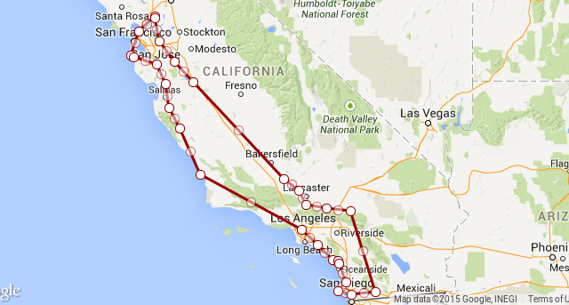
The part of this loop that's really interesting to me is that when they were close to finishing, they made a pass over Livermore (where I live). While we might have just been on the path back to Travis, it's quite possible that they wanted to take a look at NIF at LLNL. NIF is in the news because there's talk of them firing their lasers on plutonium in 2015. Maybe Russia wanted to get some "before" pictures, in case something goes horribly wrong. LLNL is the light brown block next to the 'e' in Livermore in the picture below. I believe it has a no-fly zone around it.

A Trip to Nevada (December 12th)
I didn't get any tracks for December 11th, but I did get a few points for the 12th. It looks like the plane made a trip out to Las Vegas. That grey area north west of Vegas is a big area of interest: it includes the Nevada Test Site, the Tonopah Test Range, and Area 51.

Returning to Russia (December 13th)
RA-85655 made the long journey back starting on December 13th (shown at the top of this post). I didn't get a landing point for the flight, but it did fly just south of Moscow before I lost it.

Data
Here is the data I used in this post, along with some simple instructions on how you can plot it yourself in a browser. For the record, this was all work I did in my spare time using data I collected from public sources (FlightRadar24).