Post-Superbowl Flight Data
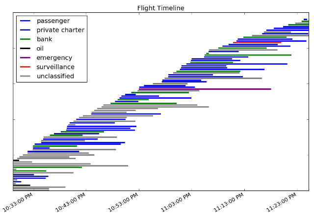
Earlier this year the local Livermore paper had some articles about how air traffic at our municipal airport was going to shoot up during the Superbowl, because there weren't going to be enough places for private jets to land in the Bay Area. I didn't think much of it at the time, since the paper tends to have delusions about how rich people will fly to Livermore and spend time here. However, after the Superbowl, my wife noticed on social media that several of her local friends were chatting about how there were a lot of jets taking off from the airport that night. I fired up dump1090 and let it grab for an hour before bed. After a bit of post-processing work, here's a timeline for all the flights I saw:

Post Processing
Dump1090 is a great program- in addition to displaying where planes are in a webpage, it produces easy-to-parse dump files that contain a good bit of plane information. I captured two types of traces from dump1090 after the Superbowl: the detailed runtime output with all the message info and the distilled, csv-formatted data from the netcat interface. The grabs went on for about an hour and yielded 30MB and 13MB of data, respectively. Looking at the data, I saw basically what I expected: there were a large number of private planes, but none of them were reporting position information. It drives me crazy that they clearly have ADS-B equipment but don't transmit position. Current regulations don't require it though, so nearly all private planes turn it off to prevent you from tracking their exact locations.
The dataset did leave me with a big pile of timestamped ADS-B IDs though, so I started looking for ways I could convert the IDs to something more interesting. I found that the FAA provides an extremely useful database you can download that contains full registration information for all US planes. The database is a collection of easily-parsed CSV files, and contains each plane's ADS-B hex code, tailfin, plane type, and owner information. The master DB files are currently close to 200MB uncompressed, but when I extracted just the ADS-B id and owner columns, it was only about 8MB (small enough for a quick lookup table use).
I used the FAA info to find the owners of the planes in my dataset, and then did some simple text processing to assign a classification to each plane to group similar owners together. Since I only had 98 planes to look at, I mostly did the classifications by hand. 36 of the planes were easy to classify because they were owned by commercial, passenger airline companies like Delta. Another 16 planes were owned by banks (fun fact: banks own more planes than any other type of company). Through some Google searches, I identified four private passenger carriers (e.g., Xojet) that took care of 7 more planes. I found 2 more planes owned by oil companies (Eaton and San Joaquin Refining) and 1 emergency helicopter (California Shock Trauma). I also found a plane owned by a gun store and another by a trucking company. There were 21 other planes in the FAA dataset that didn't turn much up in Google searches, that I marked as unclassified. That left me with 15 planes that weren't in the FAA dataset.
Foreign Planes
The FAA dataset only has info on US planes, so I figured the missing planes must all be foreign owned. I did some reading and learned that the hex IDs reported in ADS-B are from the International Civil Aviation Organization (ICAO), and that each country is assigned its own block of values in the address space. For example the US fits in A00000 to AFFFFF (which explains why I always see A's in my data), while Portugal is in 490000 to 497FFF. Annoyingly, I couldn't find an official table with all the country codes in it anywhere. I did find a website that had deduced the info and put it into a table. I grabbed it and did a lot of awking to put it into a lookup table my scripts could use. Here's where the 15 remaining planes were from, sorted by country:
C00738  22:29:12.396 22:50:48.658 Canada
C00964  22:30:02.529 22:40:50.856 Canada
C04852  22:57:57.379 23:16:09.175 Canada
C06E87  22:29:06.825 22:38:57.286 Canada
C08048  22:31:58.590 22:43:20.798 Canada
780A5B  23:16:51.247 23:21:39.138 China
780A70  22:29:07.154 22:29:44.770 China
780DA9  22:44:36.948 22:52:14.966 China
0D049E  23:22:46.770 23:25:08.781 Mexico
0D083B  22:55:46.443 23:02:04.836 Mexico
0C206B  22:44:08.180 22:50:31.290 Panama
52027A  23:10:56.513 23:19:52.647 (reserved, EUR/NAT)
899103  22:34:37.444 22:42:35.777 Taiwan
072233  22:29:13.247 22:32:35.813 unknown
A22E75  22:42:30.730 22:55:33.598 United States
The last plane there is a US plane, which should have been in the FAA database. FlightAware gave me the tail fin (N24JG), which the FAA told me had a December renewal rate. My guess is that the plane was just in-between renewals. In any case it was an interesting plane because it's owned by Jeff Gordon, Inc. Jeff Gordon is a race car driver, so I guess I did spot a celebrity. Neat.
Military/Surveillance Flights
The next unknown was 072233. I didn't find this registered anywhere, but Google searches turned the number up in lists where people monitor military plane activity. They reported this as 09-72233, which they say is a US Army UH-72A or EC45 helicopter (unarmed).
The final plane was 52027A, which caught my eye because it falls into a NATO band of the ICAO numbers (I believe). I looked it up in the raw dump1090 data and found that it also used the callsign IRONS12, which sounds like a tough-guy military callsign. I was hoping it might be the F15 that intercepted four planes during the superbowl (and escorted them to Livermore), but I think it's actually a surveillance plane. I found references to an IRONS12 callsign being used by an RC-26B with serial 920372 in the Bay Area the week before the superbowl (and leaving after). The RC-26B appears to be an Air National Guard plane with sensors for filming and tracking, and serves to "bridge the gap between Department of Defense and civil authorities". Now that I think about it, a surveillance plane is a lot more interesting than the F15s that the news covered.
Flight Times
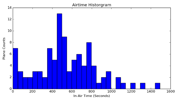
The only other analysis I did on this data was look at how long planes were in the air (or otherwise chirping their ADS-B info). Given my antenna configuration that night, most planes were only visible for about 10-15 minutes. The emergency helicopter though operated for more than 20 minutes. I'd been hoping to see some private planes with long running times (a sign that they were sitting at the airport waiting for their owners to show up), but that didn't happen.

Code
I've put the data and the scripts used to do these plots on github. The country code lookup table I made for this work is also in the repo.